|
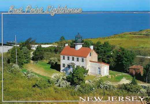
East Point lighthouse at the mouth of the Maurice River
|
|
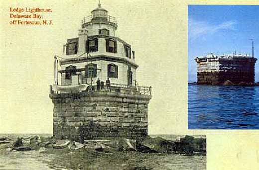
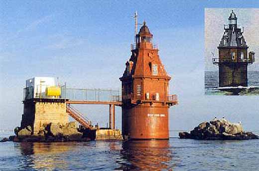
Two views, one historic and the other modern of the Cross Ledge Light of off Fortescue
The Elbow of Cross Ledge Lighthouse, located off of Fortescue, NJ was completed and lit in 1910 - and has been described as having a brown lantern on top of a red, octagonal brick dwelling, sitting on top of a brown cylindrical base. During a hurricane in 1951, The Elbow was damaged and the 4-man crew (who routinely slept in lifejackets because of repeated blows from passing ships) were removed--never to return again. The Elbow was then automated via underwater cable. On Oct. 20, 1953, during a dense fog, The Elbow was struck by a ore-laden freighter-leaving only the base and about the first 10ft. of the light! In 1954, an automated light was installed atop a red, steel skeleton tower on the original Elbow base - which still remains in operation today.
Information courtesy of Cumberland County's Lighthouses near Cumberland County Page
|
|
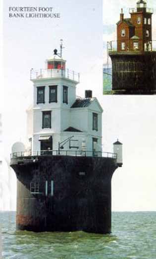
Fourteen Foot Bank Lighthouse
Fourteen Foot Bank Lighthouse is located in the lower part of the Delaware Bay on the western side of the shipping channel. The "Victorian" structure, originally brown in color, was the first U.S. lighthouse to be built on a submarine foundation with a caisson sunk by a pneumatic process -- 20 feet down into the shoal. Its 4th order Fresnel lens was lit on December 1, 1886, which allowed the Fourteen Foot Bank Lightship to be taken off the station. Sometime during the 1930s, the entire cast-iron structure -- including the "hip roof" privy located at the railing on the North West side -- was repainted white with black trim and remains the same today. Although automated and without keepers since 1972, its beacon still provides safe passage to all ships traveling the bay.
Information courtesy of Cumberland County's Lighthouses near Cumberland County Page
|
|
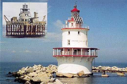
Brandywine Shoal Lighthouse
Brandywine Shoal Lighthouse is located at the southernmost part of the Delaware Bay -- N.W. of Cape May Point. It was the first screw pile lighthouse ever built in the United States. Its 3rd order Fresnel lens shove for the first time on October 28, 1850. After serving well for over 60 years, a new conical structure, requiring less maintenance, was built on a caisson of reinforced and was lit on October 20, 1914. This light station is still an important aid to navigation and was the last lighthouse in the Delaware Bay to have a keeper on board! Automation took place in 1974...the end of a once proud era!
Information courtesy of Cumberland County's Lighthouses near Cumberland County Page
|
|
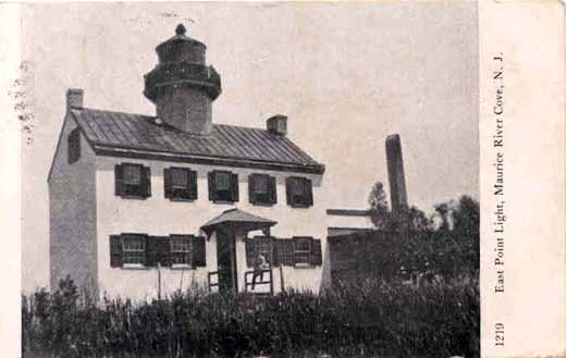
Another view of East Point Light
|
|
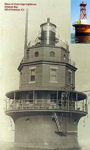
An actual historic image of Cross Ledge Lighthouse (AKA Elbow of Cross Ledge) plus an inset modern view
|
|
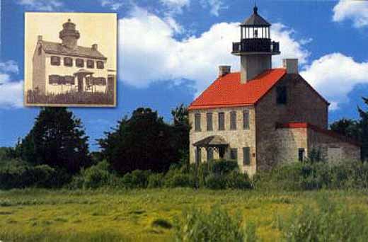
A turn of the 20th century view of East Point Lighthouse near Mauricetown
East Point Lighthouse, the last remaining beacon on the shoreline of the Delaware Bay, was built in 1849 and commissioned in 1852. In 1941, due to the onset of WW II, its 6th order flashing light was extinguished so that German submarines (known to come up into the bay) could not use it as a navigational aid. On July 15, 1971, tresspassers accidentally started a fire that gutted the upper floor and the roof of the Light. Due to the rebuilding effort of the Maurice River Historical Society, the USCG relit the beacon in July of 1980 -- and is still a working aid to navigation marking the entrance / channel to the Maurice River. Further restoration has taken place on the lighthouse in phase 1 of a restoration project and it reopened to visitors in October, 1998.
Information courtesy of Cumberland County's Lighthouses near Cumberland County Page
|
|
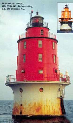
Miah Maull Shoal Lighthouse (located southeast of Fortescue)
Miah Maull Shoal Lighthouse derived its strange name from the fact that a man named Nehemiah Maull drowned near the present site in a late 18th century shipwreck. In 1909, a temporary light shone from the cast iron foundation shell which latter that year was partially filled with concrete. At last – in 1913, the permanent light was exhibited for the first time from its 4th order lens which was visible for 15 miles. Originally painted brown, Miah Maull (by 1941) was “listed” as having a red tower and watch-room, a black lantern room and sitting on a gray base. During renovation in the early 1980s, the metal canopy covering the walkway was removed by the US Coast Guard – “sadly” altering its appearance. By 1973, Miah Maull was fully automated and is still an active aid to navigation and a favorite fishing spot for many.
Information courtesy of Cumberland County's Lighthouses near Cumberland County Page
|
|
Ship John Shoal Lighthouse
The Ship John Shoal Lighthouse was named after the ship "John" wrecked in 1787 near the site of the present structure located in the northern part of the Bay near the mouth of the Cohansey River. The iron superstructure, a part of the lighthouse exhibit at the 1876 International centennial exhibition in Philadelphia, was brought to the shoal and placed in position - where it became a permanent structure in 1877. The beacon, fully automated in 1973, is today still a working guide to navigation.
Information courtesy of Cumberland County's Lighthouses near Cumberland County Page
|
|
Dividing Creek Baptist Church There is a brief Early History and a partial list of folks in the cemetary at Interment.net and a fuller history transcribed from the History of Cumberland County (Page 660 and 661) by Charles E. Sheppard at Jansdigs.com
|